Walking from Sorrento independently along local trails
Some of best walking in Italy around Sorrento's vast network of trails in peninsular
Sorrento network of trails
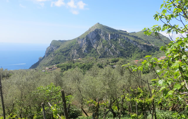
The region around Sorrento has a network of trails all around the peninsular. These are the ancient donkey trails that originally linked the villages of the peninsular.
Most of the trails are remarkably intact although little used and are typically about 3-4 metre wide stone trails very well engineered.
There are trails suitable for all ages and abilities. None are challenging for a hardcore walker. The only factor that really differentiates between trails is the steepness of the hills along the way.
In contrast to many walking districts there really is something different around every corner, plus regular opportunities for a drink or snack.
The trail network stretches all along the peninsular from Sorrento as far as Positano, Amalfi and beyond. The area at the western end of the peninsular around Sorrento is the latest. The trails further east around Positano and Amalfi are much more challenging.
Tolomeo Project network of trails Sunflower walking books Sorrento Sorrento to Massa Lubrense Walk starting from Piazza Tasso
In the Sorrento area the highest you can climb is around 500m. Most visitors will either do one of the easy, relatively flat walks like the one described below or get one of the local Sorrento buses to Sant Agata, the major town in the centre of the peninsular.
Santa Agata is the destination of most of the local buses and is at about 400m. It's a pleasant stroll downhill to Sorrento via a choice of walkways to Sorrento and Santa Agata is worth examining closer too, with a few nice cake shops and cafes.
For the serious walker there are about 5 or 6 full days of walks of around 4-5 hours in the immediate area before you will need to move onto the more hardcore trails over by Positano and beyond.
Tolomeo Project network of trails
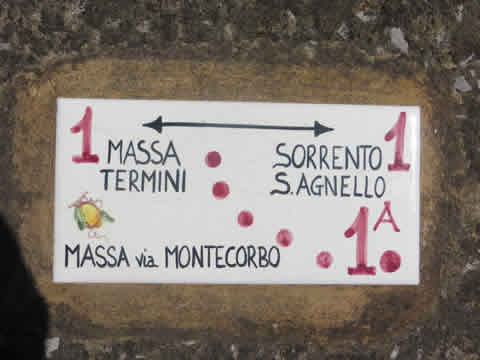
As you walk around the peninsular you will regularly come across signposts like that pictured. These are not the classic finger posts you see in most countries but small ceramic tiles you will find inlaid into a wall or the ground.
The project covered 110km of marked trails in the Sorrento, Sant Agata and Massa Lubrense district numbered 00 through to 4 with many sub-trails numbered something like 1b.
A walking map was published in 2013 and is available from tourist offices in Sorrento and is very good. However, the numbered trails you will see around the area are not marked on the map.
At key locations in the villages you will still see boards with large versions of the old map and the numbered trails marked but it looks as though these and the signs are not being maintained so will probably fade away over the coming years.
Sunflower books - Sorrento, Amalfi car tours/walks
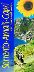
Perhaps the most popular walk book in English for the Sorrento area is by Sunflower books who publish a range of titles covering many of the popular European holiday destinations where walking is a popular diversion.
The Sorrento book covers both the western end of the peninsular and walks all along the southern coast as far east as Amalfi and beyond as well as the isle of Capri.
Unlike all the other titles of the Sunflower range that have discreet separate walks, the Sorrento book is different. Because of the interconnecting nature of all the trails on the Sorrento peninsular each segment is a mini-walk in itself. The intent is that you put together several of these segments for your own bespoke walks.
Another differentiating factor of the Sorrento Sunflower Countryside book is that there are different write-ups and timings for each direction of each segment. Timings can be very different on some of the walks with huge altitude changes.
The easiest and cheapest way to get your hands on a copy of the Sunflower book is online through Amazon, link below.
Sunflower Books - Sorrento, Amalfi Car Tours and Walks - Amazon
Sorrento to Massa Lubrense - most popular walk around Sorrento
To give you a flavour of the walks available, below are instructions for the most popular walk from Sorrento, measured by the number of people who walk it. If you do this walk you'll probably meet other tourists along the way.
The walk is about 90 minutes easy walking one-way. At Massa Lubresse there are views and bars and a frequent bus service back to Sorrento. For serious walkers this would be just the first part of a longer walk further out on the peninsular.
Under the Tolomeo network the walk is signposted as walk 1 that goes beyond Massa Lubrense to Termini. In the Sunflower book the walk makes up two separate segments. Both Tolomeo and Sunflower have more challenging alternative routes between Sorrento and Massa Lubrense.
Walk starting from Piazza Tasso

Starting out from the main square in the centre of Sorrento, Piazza Tasso, we go down the Via San Cesareo, which is the main shopping pedestrianised alley west from the square that runs parallel to the main road (Corso Italia).
You just keep going straight ignoring other alleys left and right. Gradually the shops start thinning out and you finally exit at the other end of town at a staggered junction. Going downhill (right) is the main vehicle road down to Marina Grande. Left, this road goes up to the coast road (via Capo) which you can see curving around the headland.
You, though go straight ahead, a few yards to the right then immediately left. Keep following the lane which parallels beneath the busy Via Capo above you. At some houses you think the lane is a dead end but steps and a concrete path bend around the buildings up to the busy Via Capo above.
Turn right along the pavement for about 75 yards and cross over to take the first cobbled road off left opposite Camping International.
The cobbled lane climbs. Just before a hairpin bend you will see wide stairs providing a short-cut from the hairpined lane. This climbs up to a view point and a large hotel.
You should start to see some of the Tolomeo tile waymarkers now. After admiring the view over Sorrento Town the way turns left, again uphill as the hotel grounds end on your left. If you miss the turning you will start descending, a signal to U-turn back to the hotel and take the uphill path.
The path climbs up to a main road. Turn right and you will see the continuation of the wide path/lane on the other side of the road about 100 yards down.
You can now relax for a while as the level track contours to the village of Pantano. Just follow the track/lane with olive groves and some houses, on the way you double back sharply where a water channel goes across our way. You soon come into the village of Pantano, the lane is just wide enough for a small car.
The lane bends sharp right into Pantano. At a T-junction do not go straight ahead but turn left up the wide road that climbs steeply. Again if you start descending you have missed your turning. U-turn back to the T-junction.
At the top of the climb just after the road flattens out take the dirt track veering off right, just before the main tarmac road turns left and climbs.
Ignore turn-offs and the track brings you to a large house, just before the house you will see a footpath down the left hand side of the house. This is one of only two sections of the walk where you have to walk single file in-line.
You soon pass the Best Western La Solara hotel down on your right with its pool and you contour around the hill side with panoramic views.
Climb a short flight of steps which brings you up to a narrow lane, just wide enough for the people living in the smart houses around here. Keep going straight ahead ignoring turnoffs. After 10 minutes the lane descends to a wider road.
Turn right joining this road and just 50 yards further along where the road turns right, turn left on the bend. This is the second single file section of footpath and you may wonder if this is the right way at first. Very shortly the path gradually descends until you see a wide stone staircase heading down to the main coastal road below.
Be careful on the main road and turn left. Follow the road around the tight bend. Just around the bend you will see a private drive veering off left through orange trees to a house. Just after a slight left bend fork left up a paved path which leads up to the house. The path zigzags up to the house and you might wonder if you have right of way at first as it goes through the property to a lane beyond.
The lane climbs and then starts to descend. It's now all downhill to Massa Lubrense.
Just keep going straight downhill, ignoring turnoffs. Turning a bend the road levels out just before it joins a main road. Turn right and the main road junction in the centre of Massa Lubrense is just a couple of minutes' walk. At the junction the local buses, tourist office and viewpoint is right.